The strong El Niño weather pattern that brought some much-needed rain and snow to California this past winter is rapidly weakening and climatologists expect it to be gone by late spring or early summer. Given the strength of the El Niño event this past winter, the Climate Prediction Center (CPC) of the National Weather Service has said that chances are increased for the formation of a La Niña pattern in the second half of this year.
California will get some relief from the multiyear drought as a result of the El Niño. The water content of the state’s snowpack is just 87% of the long-term average, and officials have not yet decided whether to lift the rationing program instituted last year. The winter’s wet weather delivered most of its benefit to the northern part of the state. The southern portion remains as dry as it was last year. That is not good news for agriculture in the San Joaquin Valley and areas south.
While not a mirror image of El Niño , La Niña’s effect on North American weather is quite different. These illustrations from the CPC show that the wet weather that visited California will move north to Washington and Oregon if the La Niña develops.
[recirclink id=323094]
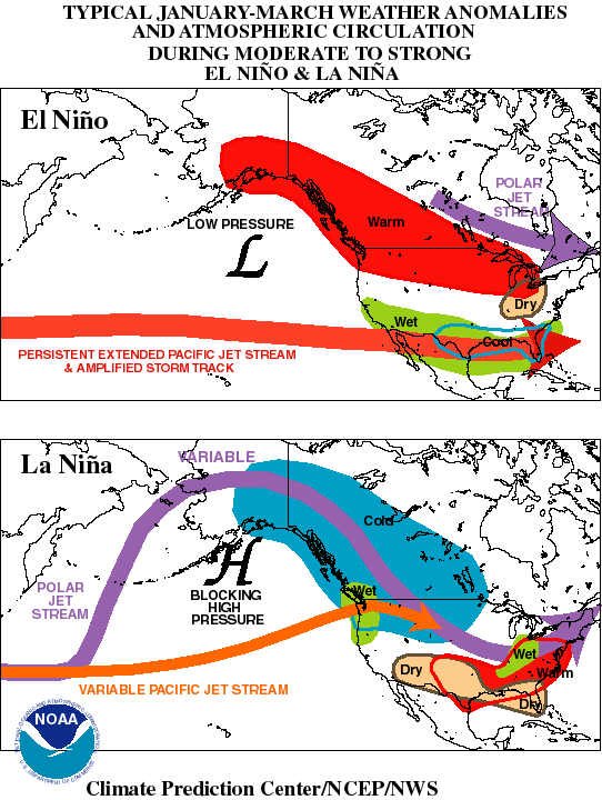
The CPC describes La Niña weather patterns this way:
[L]arge portions of central North America experience increased storminess, increased precipitation, and an increased frequency of significant cold-air outbreaks, while the southern states experiences less storminess and precipitation. Also, there tend to be considerable month-to-month variations in temperature, rainfall and storminess across central North America during the winter and spring seasons, in response to the more variable atmospheric circulation throughout the period.
La Niña can also increase the development of hurricanes in the Atlantic Ocean. The National Oceanic and Atmospheric Administration will release its outlook for the Atlantic hurricane season on May 27.
Contact [email protected] for any questions or corrections.